Wednesday 25 July 2012

Mount Roraima

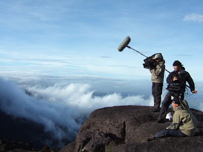
Mount Roraima: also known as Tepuy Roraima and Cerro Roraima; Portuguese: Monte Roraima is the highest of the Pakaraima chain of tepui plateau in South America. First described by the English explorer Sir Walter Raleigh in 1596, its 31 km2 summit area is defended by 400-metre-tall cliffs on all sides. The mountain includes the triple border point of Venezuela, Brazil and Guyana. Mount Roraima lies on the Guiana Shield in the southeastern corner of Venezuela's 30000 km2 Canaima National Park forming the highest peak of Guyana's Highland Range.


 Mount Roraima
Read more ...

Thursday 19 July 2012

Lake Louise

Lake Louise: is a hamlet in Alberta, Canada within Improvement District No. 9 Banff (Banff National Park).The hamlet is named for the nearby Lake Louise, which in turn was named after the Princess Louise Caroline Alberta (1848–1939), the fourth daughter of Queen Victoria, and the wife of John Campbell, the 9th Duke of Argyll, who was the Governor General of Canada from 1878 to 1883. The hamlet was originally called Laggan, and was a station along the Canadian Pacific Railway route. It was built in 1890. The train station building was preserved and moved into Heritage Park in Calgary.

 Lake Louise
 Lake Louise
 Lake Louise
 Lake Louise
 Lake Louise
Lake Louise
Read more ...

Niagara Falls

Niagara Falls: is the collective name for three waterfalls that straddle the the international border between the Canadian province of Ontario and the U.S. state of New York. They form the southern end of the Niagara Gorge. From largest to smallest, the three waterfalls are the Horseshoe Falls, the American Falls and the Bridal Veil Falls. The Horseshoe Falls lie on the Canadian side and the American Falls on the American side, separated by Goat Island. The smaller Bridal Veil Falls are also located on the American side, separated from the other waterfalls by Luna Island.

 Niagara Falls
 Niagara Falls
 Niagara Falls
 Niagara Falls
 Niagara Falls
 Niagara Falls
Read more ...

Prince Edward Island

Prince Edward Island: is a Canadian province consisting of an island of the same name, as well as other islands. The maritime province is the smallest in the nation in both land area and population. The island has a few other names: "Garden of the Gulf" referring to the pastoral scenery and lush agricultural lands throughout the province; and "Birthplace of Confederation", referring to the Charlottetown Conference in 1864, although PEI did not join the confederation until 1873, when it became the seventh Canadian province.

 Prince Edward Island
 Prince Edward Island
 Prince Edward Island
 Prince Edward Island
 Prince Edward Island
Prince Edward Island
Read more ...

Monday 16 July 2012

Maui Island

Maui Island: is the second-largest of the Hawaiian Islands at 727.2 square miles (1,883 km2) and is the 17th largest island in the United States. Maui is part of the State of Hawaiʻi and is the largest of Maui County's four islands, bigger than Molokaʻi, Lānaʻi, and unpopulated Kahoʻolawe. In 2010, Maui had a population of 144,444, third-highest of the Hawaiian Islands, behind that of Oʻahu and Hawaiʻi Island. Kahului is the largest census-designated place (CDP) on the island with a population of 26,337 as of 2010 and is the commercial and financial hub of the island.

 Maui Island
 Maui Island
 Maui Island
 Maui Island
 Maui Island
 Maui Island
Read more ...

Sunday 8 July 2012

Ulleungdo Island

Ulleungdo (also spelled Ulreungdo is a South Korean island in the Sea of Japan (East Sea). Formerly known as Dagelet to the Europeans, Ulleungdo is about 120 km (75 mi) east of the Korean Peninsula. Volcanic in origin, the rocky steep-sided island is the top of a large stratovolcano which rises from the seafloor, reaching a maximum elevation of 984 metres (3,228 ft) at Seonginbong Peak. The island consists primarily of trachyandesite rock. A major explosive eruption about 9,350 years ago reached a Volcanic Explosivity Index of 6 and deposited tephra as far as central Honshū over 800 km (500 mi) away.

 Ulleungdo Island
 Ulleungdo Island
 Ulleungdo Island
 Ulleungdo Island
 Ulleungdo Island
Ulleungdo Island
Read more ...

Ninja Temple Kanazawa

Ninja Temple Kanazawa: Kanazawa is the capital city of Ishikawa Prefecture, Japan. Kanazawa sits on the Sea of Japan, bordered by the Japan Alps, Hakusan National Park and Noto Peninsula National Park. The city sits between the Sai and Asano rivers. Its total area is 467.77 km². Kanazawa's weather is temperate though rainy. Average temperatures are slightly cooler than those of Tokyo though, with means approximately 4 °C in January, 15 °C in April, 25 °C in July and August, 15 °C in October, and 5 °C in December. The minimum temperature on record was −9.4 °C (15.1 °F) on January 27, 1904, with a maximum of 38.5 °C (101.3 °F) standing as a record since September 8, 1902.

 Ninja Temple Kanazawa
 Ninja Temple Kanazawa
 Ninja Temple Kanazawa
 Ninja Temple Kanazawa
 Ninja Temple Kanazawa
Ninja Temple Kanazawa
Read more ...

Wednesday 4 July 2012

Hickory Nut Falls

Hickory Nut Falls: also known as Hickorynut Falls, is a waterfall located at Chimney Rock State Park in Rutherford County, North Carolina. Hickory Nut Falls flows on Fall Creek through the Hickory Nut Gorge, and is part of Chimney Rock Park, a park that was privately owned until May 2007, when the State of North Carolina completed the purchase of the park. Chimney Rock Park and the Hickory Nut Gorge are being developed into a state park. Prior to 2007, the park and the falls was owned by the Morse family, and was widely known to Southerners for over 100 years.

 Hickory Nut Falls
 Hickory Nut Falls
 Hickory Nut Falls
 Hickory Nut Falls
 Hickory Nut Falls
 Hickory Nut Falls
Read more ...

Chimney Rock

Chimney Rock: is a prominent geological rock formation in Morrill County in western Nebraska. Rising nearly 300 feet (91 m) above the surrounding North Platte River valley, the peak of Chimney Rock is 4,226 feet (1,288 m) above sea level. During the middle 19th century it served as a landmark along the Oregon Trail, the California Trail, and the Mormon Trail, which ran along the north side of the rock. It is visible for many miles from the east along U.S. Route 26. The first recorded mention of 'Chimney Rock' was in 1827 by Joshua Pilcher. Pilcher had journeyed up the Platte River valley to the Salt Lake rendezvous of the Rocky Mountain fur trappers.

 Chimney Rock
 Chimney Rock
 Chimney Rock
 Chimney Rock
 Chimney Rock
Chimney Rock
Read more ...

Tags

Aquariums (5) Beaches (3) Bridges (4) Buildings (6) Castles (3) Caves (2) Cities (14) Falls (6) Forests (2) Hotels (3) Islands (18) Mountains (7) Roller Coasters (7) Valleys (6) Wonders (5)

Popular Articles

Contact us

Name

Email *

Message *